GIS & Digital Mapping Solutions

Geographic Information Systems, mapping and spatial data consultancy unlocking The Value of Where®

ESRI Silver Partner with ArcGIS Online Specialty

GIS & Digital Mapping Solutions

Organisations invest significant amounts of money in data, much of which is geospatial data. To release the value in this investment you need a Strategy and a System to support it.

Mapman provides Geographical Information System and digital mapping consultancy services and solutions – enabling you to unlock The Value of Where®.

Contact Mapman to book a free initial consultation

Mapman provides the location strategy and systems you need to thrive

Location Strategy

Data-driven organisations understand information, and this understanding lives in the data. This is data you already have in your business systems (e.g. CRMs), your head, spreadsheets, documents, images, and more. All of this data has one thing in common – location.

A Location Strategy is required to manage this data and derive understanding.

Business value: gather, visualise and analyse data, bringing the purpose of GIS - to deliver actionable information - to the forefront.

Location Strategy diagram
Land, People, Property System

Geographical Information Systems

Managing data in a structured, organised manner is what a GIS does well. Harnessing your location data enables you to leverage its value. This is done by ensuring your teams and their clients have the most accurate and timely data in their hands.

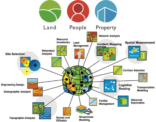
GIS enables organisations to gain deeper insight into key geospatial business data (Land, People, Property) using location analytics.

GIS mapping software helps you understand and visualize data to make decisions based on the best information and analysis.

Mapman specialises in Esri's ArcGIS Platform - the world's leading provider of GIS - via the Esri Partner Network.

Some testimonials

Alex CornwallisDirector, BTF Partnership
Read More
A high quality service with fantastic mapping ability. Pete was able to provide us with exactly what we required for some high end property sales brochures which our clients were thoroughly impressed with. Quick, easy to deal with and efficient.
Christine LyonsHead of Planning, Hertsmere Borough Council
Read More
Excellent work from Peter. Providing Hertsmere with excellent direction and support. The recommendations we received provided options for the Council as a whole.
Karen BerryFounder & Director, Bamberry Consulting
Read More
Peter successfully completed a GIS review for the London Borough of Hillingdon and produced a well thought out and comprehensive report offering a number of solutions designed to enhance their service. He was hand-picked for the assignment because of his in-depth knowledge and experience of GIS and digital mapping, particularly in the public sector. He is a true professional and delivered the project ahead of time and I would not hesitate to recommend Peter for any GIS and digital mapping projects for business and for our public sector clients.
Alison DrayHighways Asset Manager, Wokingham Borough Council
Read More
Peter prepared a web-enabled consultation for Traffic Regulation Orders using mapping which delivered an easy consultation process and a better service for our customers. Working with Peter was an ideal professional experience. He is an excellent listener, who understood our business needs and offered solutions that enhanced our service. He delivered on time and budget whilst adding value along the way with his collaborative and technically sound approach.
Brian HughesConsultant, NCC Group
Read More
I worked in collaboration with Peter to review the viability of corporate mapping options for a client and found Peter to be a highly professional and pragmatic consultant. Peter’s in-depth, practical experience and knowledge of the GIS and digital mapping ‘world’ enabled us to effectively derive a set of options that were business-focused, strategic and robust. The client was able to objectively select their preferred option from those presented and are now, with Peter’s support, in the process of implementing the selected option. I would not hesitate to recommend Peter for any work that focused on GIS and digital mapping for business.
Fiona PennyOwner & Director, Fiona Penny Bespoke Home Finders
Read More
Peter is extremely professional and listened carefully to our feedback. He has some innovative ideas and is able to relate these ideas to different business models. The Cranbrook School Catchment Area app which he developed for us is a fantastic tool which is proving to be very well received and it helps to differentiate us. I would not hesitate in recommending Peter to anyone else who requires his expert digital mapping input.
Paul TaylorDirector, Mid Kent Services
Read More
Peter’s strategic insight and knowledge of GIS is first class. I have worked with him over a number of years directly and in partnerships across Kent and he has always impressed me with the way he helps and supports others. He has strong values and high standards and I thoroughly enjoyed working with him.
William BensonChief Executive, Tunbridge Wells Borough Council
Read More
Pete led our GIS services at Tunbridge Wells Borough Council and more widely across a number of authorities in Kent. A strategic thinker, Pete was passionate about sharing and exploiting data for the benefit of citizens and public service providers alike and about harnessing the power of data to transform services.
Previous
Next

...or ask us to create something just for you

The Value of Where®

We use spatial data and analytics to answer high value questions and solve complex, often systemic, problems.

Geography provides a where to the who, what, when and why.

Location, location, location: everything happens somewhere!

Clients for whom we've
unlocked The Value of Where®...